THIS BLOG IS NO LONGER UPDATED

Please see http://www.scotland-landscapes.com/new-articles/ for our continued blog and browse our full site at http://www.scotland-landscapes.com.

Thanks for your support
Jason Bonniface, Scotland-Landscapes.com

Friday 5 November 2010

13th & 14th Oct 2010 - Giants Staircase, Grey Corries, Aonachs & Ben Nevis

Its about time to be thinking of how to make use of the snow thats beginning to fall on the hills, but before that I'm going to reminisce, looking back three weeks to warm sunshine and a t-shirt on the crest of the Grey Corries with a sea of cloud blanketing all but the highest peaks in every direction.

High pressure was in charge and a temperature inversion was in place for several days. Fortunately this coincided with the half term holidays and a trip to the parents/grandparents who seemed to be willing childminders! On the Wednesday morning I had a slow start finally getting going from Coire Choille near Spean Bridge at about . The plan was to head into the Lairig Leacach at the east end of the Grey Corries and then ascend Stob Choire Claurigh via the Giant’s Staircase scramble detailed in Noel Williams Scrambles in Lochaber. After that I hoped to continue along the Grey Corries ridge to its end and then on to the Aonachs, Carn Mor Dearg and Ben Nevis beyond with an overnight camp somewhere near the Aonachs.

Interactive map of the route

Its a fair walk in to the Lairig Leacach Bothy. Its been a few years since I was last there and the track dragged on for a couple of hours. On the way I was surprised to notice several private vehicles had been driven a mile or so past Coire Choille and this would have saved a half hour or so. I hate track walking! The weather wasn’t too promising either, several days before had been stunning once low cloud had dissipated but it looked thicker and more stubborn. From the bothy I followed the peaty path into Coire Claurigh to the base of the Giants Staircase.

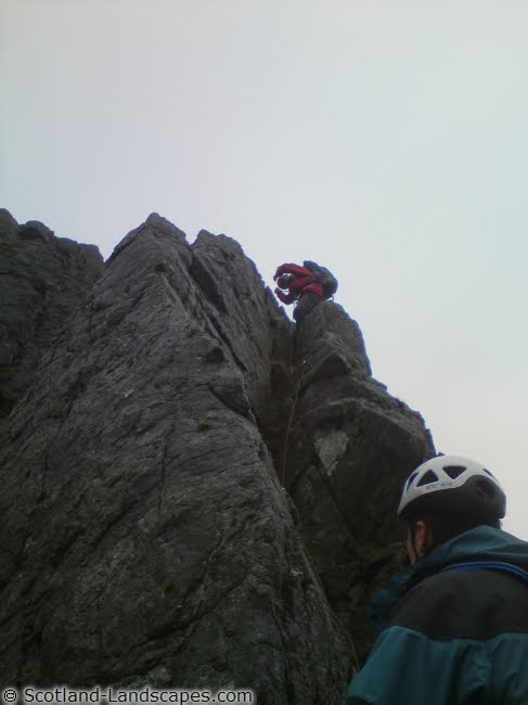
The Giants Staircase a Grade 2 scramble described by Noel Williams as “quite the best scramble on such rock (quartzite) in Lochaber” carried me up into the mist. The slabs proved to be very enjoyable with minimal exposure and plenty of choice of route due to the stepped “staircase” nature of the terrain. It seemed to me an ideal place to bring children for a taste of mountain scrambling (the down side being the length of the walk in, but a bike ride would make it enjoyable).

On reaching the bealach between Stob Ban and Stob Choire Claurigh I turned north for the latter peak with hints of sun and blue sky just above. Before long I emerged into a different world.

Stob Coire Cath na Sine being swallowed up from the slopes of Stob Choire Claurigh. For the rest of the day the ridge would periodically appear and then be enveloped again.

The Grey Corries, Aonachs and Ben Nevis from the summit of Stob Choire Claurigh.

On the summit of Stob Choire Claurigh it was approaching and due to be dark by about . I moved off west along the ridge quite mindful of the time. The ridge was not completely deserted with one other chap heading east and we remarked on our good fortune. I met no one else until the summit slopes of Ben Nevis next day.

The view back east along the ridge to Stob Choire Claurigh. A glory surrounds my shadow on the lower left.

Stob Coire an Laoigh and Stob Coire Easain

A sea of cloud from Stob Coire an Laoigh. The top surface of the cloud was at about 1000m so only a select few peaks were showing.

I usually pride myself on being able to identify most surrounding peaks and whilst I made good guesses at most of these, the cloud made it difficult to judge directions and distances. These were worked out with the aid of Geographical Information Systems (GIS) software.

By the time I was reaching the summit of Sgurr Choinnich Mor it had passed and the sun was making a swift descent. The cloud level was also rising and I descended into it on the descent towards Sgurr Choinnich Beag.

A brocken spectre on the summit of Sgurr Choinnich Mor

I’d climbed all the munros and tops on this route previously but had never linked the Grey Corries and Aonachs, and Aonachs and Carn Mor Dearg. There is steep ground on both sides of the Aonachs and I approached the ascent towards Stob Coire Bhealaich, a top of Aonach Beag, hoping the route would be obvious. A small but initially clear path led west from spot height 731m but in the quickly fading light and a jumble of rocks I lost it in no time. Instead I followed a dry stone wall up steep rocky slopes towards the base of a crag defending the ridge between Sgurr a’ Bhuic and Stob Coire Bhealaich. Below the crag there was a grassy ramp slanting up northwards towards the crest of a minor ridge. It was pretty gloomy and after by this point and I used the remains of my energy to follow the ramp upwards hoping the ridge would provide a route through the crags onto the main ridge. Fortunately it proved to be so, with a faint path winding up the mossy, shaley ridge providing some confidence. I gratefully reached the main ridge and found a grassy slope to pitch the tent by torchlight, crawling into it for food, a good read and a night of slipping down the slope to the end of the tent!

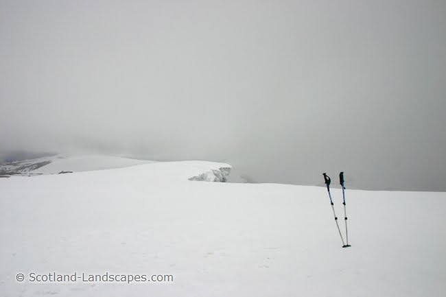
I poked my head out of the tent at 06:30 to find the cloud had risen above my campsite during the night and that I had a good, if still fairly dark, view of the Mamores. Unfortunately as I packed everything up the cloud came back down accompanied by mizzle.
The wander over Aonach Beag to Aonach Mor and back south to the route down towards the bealach between the Aonachs and Carn Mor Dearg was uneventful apart from the occasional glimpse of a view through a parting of the clouds. The descent route west off Aonach Mor was marked by a small cairn and easy enough to find in the murk.

Looking back from the slopes of Carn Mor Dearg.The small path off Aonach Mor led down the ridge and into a steep gully (centre left) towards the north side of the bealach.

A drizzly Carn Mor Dearg. Its east ridge (centre left) was a straight forward plod. The east ridge of Carn Dearg Meadhonach is apparently a grade 1 scramble but looks interesting (in the mist on the right). 

The Carn Mor Dearg (CMD) Arete provided a straightforward scramble, really just boulder hopping on a ridge, round to the slopes of the Ben in the cloud, the granite giving fairly reliable grip even in the damp conditions.

Fort William and Loch Linnhe from the upper slopes of Ben Nevis

Good timing. The kids, Granny and Grandad, eating lunch on the path up to Coire Leis. Lunch and a lift back to Coire Choille were provided free of charge! 

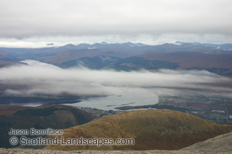
A departing autumnal view back to Coire Leis and the north face of Ben Nevis.

See more photos at Scotland-Landscapes.com 
Prints of all Scotland-Landscapes photos are available to buy online at Photobox.

Jason Bonniface, 05/11/2010
© Scotland-Landscapes.com

Sunday 24 October 2010

September 2010 - Ben Hope Scrambles (Brown's Ridge & Petticoat Ridge)

The publication of the SMC guide, Highland Scrambles North, to scrambles in the northern Highland's has added a new dimension to the possibilities in the area giving pointers towards routes and faces that in the main I just wouldn't have looked at.

The book details two scrambles on Ben Hope's north-west face; Brown's Ridge and Petticoat Ridge. The face is complex and the approaches to Petticoat Ridge are not too obvious on first sight. Also on the face is Bell's Ridge ("much harder than scrambling") which merges with the mountains main north ridge a little below the summit. The merged ridge has a difficult and exposed rock step just above where the 2 ridges join.

Interactive map showing the approximate positions of Brown's Ridge to the north and Petticoat Ridge further south.

Ben Hope is mainly tackled by its southern flank which doesn't do the hill great justice. In reality it is a wild beautiful hill with much more to offer. These photos and illustrations are intended to shed some more light on the routes on the north west face and north ridge.

Ben Hope from Hope to the north taken in the early evening. A classic view of the hill and one that does its northern and western ramparts justice.

Ben Loyal from the south west on the Hope to Altnaharra road.

The north-west face of Ben Hope in summer and winter. Highland Scrambles North details two routes of approach to Petticoat Ridge, one from the base of the face via the "rake" and one a descent from the summit. I climbed Brown's ridge and then used the line of descent described in the book, and marked here, to get to Petticoat ridge.

The lower section of Brown's ridge. I believe the route described in Highland Scrambles North is the left hand of the 2 marked higher up, but alone without a rope, I opted for what looked like an easier less exposed variation to the right.

Brown's Ridge rises to the minor top on Ben Hope's north ridge (spot height 819m).

The summit area of Ben Hope from the minor top. The north ridge's exposed rock step seen here on the right hand skyline just above the point where Bell's Ridge joins the main ridge. The obvious grassy gully a little to the left has a path kicked in to its turf and provides an easy summer route which can turn into an entertaining snow and ice gully in winter requiring ice axe, crampons and care.

A close up of the tricky rock step (graded V. Diff). It doesn't look too bad in dry conditions but there is a big drop below to the right.

Highland Scrambles North describes the descent from the summit plateau down the "first major ridge south of Tower Ridge" as "intricate and serious". Care is definitely needed to identify a safe route down though the ground on the route described isn't actually too bad.

I wouldn't try to find it for the first time in mist though!

The lower section of Petticoat ridge. The lowest rock step is graded Difficult and I didn't explore it, joining the ridge instead using the "second grass rake" seen just right of the middle of the photo and avoiding the vertical block above by ledges to the right.

The upper section of Petticoat Ridge on the left skyline - an interesting series of blocks without great exposure unless you venture to the north side of the ridge. It joins the main north ridge just above and south of the rock step leaving just a few easy steps to the summit plateau. The tower of Tower Ridge is obvious on the upper right of the photo.

By the way, I should probably add some sort of disclaimer on these routes and the blog in general. The photos, illustrations, descriptions and views expressed in this blog and on our main website http://www.scotland-landscapes.com/ are given in good faith for information only and any use of them are at the readers own risk. Whilst we make significant efforts to ensure the accuracy of the information provided we cannot guarentee complete accuracy. These are serious routes requiring good levels of fitness, navigation and some technical ability. The degree of techinical difficulty will vary hugely dependant on season and conditions. You should not venture on to them without well founded confidence in your own abilities.We accept no responsibility or liability arising from reliance upon the information.

See more photos at Scotland-Landscapes.com

Prints of all Scotland-Landscapes photos are available to buy online at Photobox.

Jason Bonniface, 24/10/2010
© Scotland-Landscapes.com

Saturday 24 July 2010

28 - 30th May 2010 - Lochaber Scrambles

In late May a party of long suffering fathers managed to engineer permission from their ladies to embark on a short foray into Lochaber to tackle several of the areas scrambles. Photos and descriptions by Gavin Coppins of Scotland-Landscapes.com:

28th May 2010
Evening ascent of Curved Ridge on Buachaille Etive Mor. Setting off at 1730, the car park was deserted and the aim was to climb Curved Ridge and Crowberry Tower in time to return to the Glencoe campsite before dark.

Looking down the lower section of Curved Ridge. The ground is steep and fairly exposed but the holds were plentiful and good.

The crux move near the top of Curved Ridge. The move is enclosed in a corner so didn't feel too exposed.

The Rannoch Wall from the base of the crux move.

View south from the summit of Crowberry Tower across Glen Etive to Stob Ghabar in the background on the left and Stob Coir' an Albannaich on the right.

View across Loch Lhinnie to the hills of Ardgour (the target for the next day) from the summit of the Buachaille. The Ballachulish Bridge is in the centre of the photo.

29 May 2010
An early start and off to the Corran Ferry to Ardgour to climb Garbh Bheinn. The target was Pinnacle Ridge, a little known grade 3(s) scramble. There is a good description of the route at outdoorsmagic.com.

View of Garbh Bheinn’s Pinnacle Ridge. It was raining fairly steadily and the cloud was closing in fast. We decided to walk up to the first pinnacle to have a look. This turned out to be the crux and was quite awkward. A rope and protection were welcome as a 30m section that ascends a series of exposed grooves and ledges felt harder than a scramble in the greasy conditions.

Caterpillar on the first pinnacle.

Towards the top of the ridge, the route narrows into a fabulous arête which is more akin to something on Skye. What makes this special is that there is hardly any sign of a worn route and there is first ascent feel about the place.

The final section of the arête. This groove is steep but easily climbed to reach the vegetated terrace above. After this the route wasn't so obvious and a large slab had to be ascended. Beyond a further narrow crest led to easy ground and the summit.

29 May 2010
After another sleepless night in a packed campsite in Glencoe, it was time to head home. En-route, we decided to tackle A’Chailleach which is a grade 3 scramble that can be used to extend a traverse of the Aonach Eagach ridge. The route begins from The Study in Glencoe. The lower sections offer really nice scrambling and major difficulties can be bypassed if the conditions are not great. The only major difficulty on the route is the orange rhyolite band near the top but again this can be bypassed.

Climbing the crux of the route – an amazing situation and definitely at the limit of what can be called a scramble.

See more photos at Scotland-Landscapes.com

Prints of all Scotland-Landscapes photos are available to buy online

Gavin Coppins, 24/07/2010
© Scotland-Landscapes.com

Tuesday 8 June 2010

9th May 2010 - Bynack More Ski

With the snow little changed from the previous week the opportunity to get a swift few hours out on the hill was too much to resist. The thought of a quick tour over the flank of Cairngorm with a ski down to The Saddle and back round via Bynack More and Strath Nethy seemed like a good option.
Interactive map of the route

Seven am at the Coire na Ciste car park in a fine mizzle with the cloud at about 800m didn't make an inspiring start to the day but the forecast was for brighter weather to appear. After snow showers and thick layers of murk on the ascent of the Ciste Gully the promised clearing came in the nick of time as I pondered whether to descend towards The Saddle or not.

The clouds parting to reveal Bheinn Mheadhoin, from the head of Ciste Mhearad on the north east side of Cairngorm, just south east of the top of the ski centre's Ptarmigan Tow.

The descent to The Saddle gave an excellent 1000ft of skiing at first on wide open fresh powder breaking down into more patchy spring snow lower down. 

The descent route to The Saddle

The summit of Bynack More from A' Choinneach, the Barns of Bynack granite tors on the right hand side.

Wide open views across Glen Avon to Ben Avon and Beinn a' Bhuird, both hills still well coated with snow. 

The view south from Bynack More. The Lairig an Laoigh is the prominent pass between Beinn a' Chaorainn on the left and Beinn Mheadhoin in the centre, Ben Macdui rising above all on the right.

North to Moray beyond Meall a' Bhuachaille

The broken descent of Bynack More's north west flank.

A long ribbon of snow provided "narrow" skiing all the way down the Allt a' Choire Dhuibh to nearly 700m. All that remained was the plod down into Strath Nethy and back up over its western ramparts to re-gain the Coire na Ciste car park!

See more photos at Scotland-Landscapes.com
Prints of all Scotland-Landscapes photos are available to buy online

Jason Bonniface, 08/06/2010
© Scotland-Landscapes.com

Saturday 15 May 2010

2nd May 2010 - Ben Macdui & Braeriach Ski

I've been desperate to ski from Ben Macdui down into the Lairig Ghru for a while but have been too busy ticking munros, or not in the right place at the right time until now. I got the chance on Sunday 2nd May though, and although the weather wasn't great it was just as good as I'd hoped for. With a bit of extra effort I got the added bonus of Braeriach and a wonderful ski descent of the wide open snow slopes of Coire Gorm at the north end of Sron na Lairige as well.

Here's an interactive map of the days route courtesy of the newish Ordnance Survey Openspace service which I'll hopefully be making more use of (there are some compatibility issues particularly with IE8, and the route and or map might not show up unless you turn on compatibility view under the Tools menu!).
Interactive map of the route

Early morning ice in the stream draining Coire an Lochain

Morning mist over Braeriach.

Footsteps across the plateau to Ben Macdui

Me on the top of Macdui with Cairn Toul on the left and Sgor an Lochain Uaine (The Angel's Peak) above my head. I'm standing on the top of the shelter seen below towards the end of May 2008!

Ben Macdui 24th May 2008 - a little less snow about

Ben Macdui ski descent route down the Allt a' Choire Mhoir

Gentle skiing in fresh May powder off the summit before it steepened up

After the thaw at the end of April and then re-freezing, conditions in the Allt a' Choire Mhoir were a bit icey but free from avalanche danger. I wouldn't be keen on these slopes after any great amount of fresh snow. The stream gully itself looks quite steep and narrow and had a cornice on one side making escape tricky, so I made use of the broad bowl on its north side. The route of ascent to Braeriach marked on the other side of the Lairig Ghru.

Looking back up the Allt a' Choire Mhoir

Carn a' Mhaim, the southern end of the Lairig Ghru and Cairn Toul from the nameless east ridge of Braeriach, an unlikely perched granite boulder on the crest of the ridge.

The summit of Braeriach, all trace of it obliterated by snow. Some large cornices too.

Gentle wide open slopes in Sron na Lairige's Coire Gorm gave lovely skiing right down to the end of the ribbon of snow down the Allt a' Choire Ghuirm (curving to the left of the photo). With short walks in between I was able to link snow patches down to the base of the Lairig Ghru to the junction with the Chalamain Gap path.

One last plod over the moor from the Chalamain Gap to the Cairngorm Ski Centre with Coire an t-Sneachda above. A rough pathless end to the day, to be greeted by hordes of skiers and sightseers at the car park.

Coming soon: Bynack More ski

See more photos at Scotland-Landscapes.com
Prints of all Scotland-Landscapes photos are available to buy online

Jason Bonniface, 15/05/2010
© Scotland-Landscapes.com