THIS BLOG IS NO LONGER UPDATED

Please see http://www.scotland-landscapes.com/new-articles/ for our continued blog and browse our full site at http://www.scotland-landscapes.com.

Thanks for your support
Jason Bonniface, Scotland-Landscapes.com

Monday, 9 May 2011

March & April 2011 - From Winter to Spring in Sutherland

I had a busy March and April spending some quality time out in Sutherland and the Cairngorms whilst watching the lovely snow recede rapidly in the ludicrously mild conditions, a big let down after the prolonged snow of 2010.

Its taken a while to sort through all the photos and come up with a coherent post (hopefully a Cairngorms one to follow as well). This one details 3 good Sutherland hill routes and tracks the onset of the mild spring weather.

On the 12th March the snow began to fall on the Cairngorms and surrounding areas. It initially came on a gentle southerly air flow, following preceding days of very strong westerly winds that had blown exposed slopes and ridges clear and led to accumulations on eastern slopes. The new snow quickly accumulated leading to the closure of the Cairngorm ski road and centre for a time.

Sunday 13th March 2011 in Tomatin. 45cm of snow had accumulated in the previous 20 hours

By the end of the 13th and into the 14th heavy precipitation falling as snow over northern hills, fell after winds turned north easterly and strengthened. This soon gave way to a south westerly airflow rotating around the northern edge of a high pressure system situated over southern England and France. Its this high pressure systems presence for much of the time since that has led to the mild temperatures, much to my disappointment!

Ben Klibreck Ski Tour - 18th & 19th March 2011

Ben Griam Mor in the sun through a snow shower on a Friday evening after work en route to Klibreck

A full moon providing beautiful light over Ben Klibreck and the Altnaharra area

A stunning sunrise over Sutherland too. Ben Griam Mor is to the left and Morvern's shapely summit is peaking over the skyline on the right, from near the east coast


Interactive map of the ski route on Ben Klibreck

There are more direct routes to Meall nan Con but traversing the undulating ridge from the west gives a good ski tour in the right conditions. After a good snow fall its quite often possible to ski from and to the roadside.

Ben Klibreck from Cnoc Sgriodain

There was plenty of snow on northerly, easterly and south westerly aspects but also bare aspects blown clear by strong winds discussed above.

Meall nan Con, the summit cone of Ben Klibreck from the south west. Ben Loyal in the distance to the left

The summit cone of Meall nan Con is fairly steep and regularly holds good snow providing a remote and exhilarating ski.

A proud stag on the lowest slopes of Ben Hope in Strathmore on the afternoon of the 19th March

Shaggy highland cattle further north along Strathmore

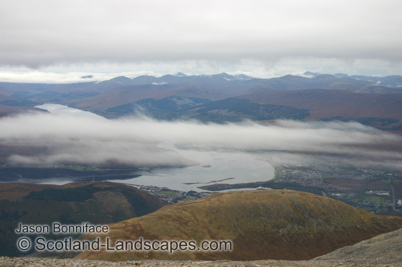
Ben Griam Mor - 25th March

Evening rays of sun over Loch Naver a week later on the 25th March after a week of mild temperatures and rapid melting

Stac Pollaidh Scramble & Ben More Assynt Ski - 2nd & 3rd April 2011

Spring in full swing on Stac Pollaidh

A scramble up the east ridge (on the right), along the summit ridge and down a gully near the western end of the hill, was an afternoon jaunt on the 2nd April.

A sepia view along the summit ridge of Stac Pollaidh with the spectacular weathered Torridonian Sandstone pinnacles of the south face on the left

The Summer Isles highlighted in the sun from the summit of Stac Pollaidh

Cul Mor (left) and Suilven (right) from the shores of Loch Borralan early on the morning of the 3rd April


Interactive map of the route on Ben More Assynt

The easterly approach to Ben More Assynt is fairly lengthy and I don't get the impression that the estate is geared up for walkers. Once the track climbs out of the Glen the going is actually along good tracks which allow rapid coverage of the distance, but unfortunately the upper Glen Cassley is blighted by a massive pipeline and ageing hydroelectric works which tie in to the Loch Shin hydro scheme.

A blight on the landscape

According to Renewable Energy in Scotland - Wikipedia 1.3 Giga Watts of electricity is supplied by hydro electric schemes in Scotland, around 13% of the countries generating capacity. In comparison Hunterston B & Torness nuclear power stations in southern Scotland produce a total of around 2.4 GW (Wikipedia - Nuclear power in the UK). Anyone who has explored the Scottish Highlands extensively will know that many, many glens have been ravaged by unsightly pipelines, dams and other concrete structures to produce the 1.3GW, not to mention the number of glens obliterated by flooding, and the human misery and upheaval associated with this and the original construction works (much of it in the 1950's). It just does not make sense to blight large tracts of land like this for comparatively small amounts of energy production when small areas of current industrial sites can be developed for new nuclear power or modern cleaner gas or coal power stations. The landscape of the Highlands, and Scotland in general, is its greatest asset, and the Scottish Governments current energy policy is driving us headlong into ravaging massive tracts of land with ugly, noisy, environmentally disastrous, ineffective and expensive wind turbines, and the tracks and infrastructure that go with them across the hills. The only benefit of these is to the land owners who give over "their" land to it.

Back to the beauty......

The summit of Ben More Assynt - the last remnants of winter in Sutherland

A nice ski down from the ridge between Ben More Assynt and its south top

I'm no extreme skier and the top section off the ridge was a touch steep for me so I scrambled down the centre rocks till the angle became a little more forgiving. My turns can be made out in the centre before I traversed down to the left of the picture. In hindsight I should have just taken on the steep gully from the ridge and gained that extra satisfaction afterwards.

Back to Ben More Assynt across the bog

Ben Klibreck on the afternoon of 3rd April 2011. A big change in 2 weeks

Conival South Ridge Scramble - 22nd April 2011


Interactive map of the route on Conival

Primroses in the sun - a definite sign of spring

The south ridge of Conival (right)

The south ridge of Conival is a grade 2 scramble according to Highland Scrambles North but unless the trickiest lines are sought out on the lower blocks I think this might be too high. Certainly, I don't believe the unavoidable sections on the upper ridge warrant more than a grade 1. Its an entertaining alternative to the standard route on the hill though, with an interesting approach up Gleann Dubh and the River Traligill and through the bealach between Conival and Breabag. The geology of this area is tremendous being situated in the "Assynt Window" of the Moine Thrust Zone.

Last snows - Ben More Assynt from Conival

Evening sun over Loch Assynt and Quinag

Sunset over Loch Assynt and Quinag from the slopes of Beinn an Fhurain above Gleann Dubh

See more photos at Scotland-Landscapes.com
Prints of selected Scotland-Landscapes photos are available to buy online at Photobox.

Jason Bonniface, 09/05/2011
© Scotland-Landscapes.com

Sunday, 20 February 2011

5th & 6th Feb 2011 - Sutherland Tour & Ben Wyvis Ski

Its been too long since the last post on here but trips out have been limited to Ben Hope and Cairngorm until recently and I haven't had too much thats new to add, or time to do it.

I managed to get out over the 5-6th Feb though, taking a tour along the north coast in search of interesting views and some exercise with a vague plan to nip up Ben Stack near Scourie in time for sunset and then see if anything looked skiable the following day.

Interactive map showing the locations of all photos featured. The numbered markers indicate numbers of closely spaced photos which become individual markers on zooming in.

The saturday was showery and bright inbetween and gave some good views across the northern hills.

Ben Loyal and Moine House on the Moine (A' Mhoine) peninsula between Tongue and Hope during a shower.

There is interesting information about the Moine House at: http://cmy.iay.org.uk/moinehouse/moine.htm and more local information on the site.

Ben Hope from a short way west of Moine House at the eastern boundary of the North West Highlands Geopark.

The stunning beach at Ceannabeinne near Durness. An amazingly beautiful place.

The Kyle of Durness with the sun beginning to sink lower towards the south west.

Trees surrounding Gualin House silhouetted on the skyline.

Gualin House is an estate hunting lodge situated at the high point of the road between Durness and Rhiconich with stunning views of Beinn Spionnaidh, Cranstackie, Strath Dionard and Foinaven's northern ramparts.

I arrived at the bottom of Ben Stack around 1530, a bit later than planned, but everything looked good for a quick ascent.

The final rays of sun on Meall Horn with Meallan Liath Coire Mhic Dhughaill on the right.

These hills are fine corbetts in wild country south of Foinaven. The photo above was taken from the mid slopes of Ben Stack.

The summit cone of Ben Stack with a dusting of snow.

This gave a pleasant plod but unfortunately the sun had gone behind cloud sitting on the horizon and more cloud descended whilst I was on the top, so there were no spectacular sunset views. By the time I'd summited and regained this location it was 1720 and getting fairly dark. The lower boggy slopes were negotiated in the gathering darkness but managed without torch light for a wee challenge.

Sunday dawned cloudy, damp and cool.

I had wondered if the upper slopes of Quinag might be skiable, having assumed that the weather wouldn't be suitable for a foray onto Conival and Ben More Assynt to ski, but as far as I could make out there just wasn't enough snow to make it worth a look, and besides, it was pretty much buried in cloud. As it was I had some decisions to make so I took a drive south in search of more snow and clearer weather. Strangely, An Teallach seemed to be the clearest munro about as I headed towards Ullapool, but I decided against it in favour of a look at ski possibilities on Am Faochagach. The west side of this hill had been blown clear of snow and the eastern approach was too long for the day. Ben Wyvis however, looked almost clear of cloud and I suspected its eastern corries would have good snow cover.

After all the driving I had a lateish start. The weather hinted at improving until lunchtime when I went into cloud at about 800m in Coire na Feithe Riabhaich on the east side of An Cabar. From there it was compass bearings to the wind swept summit and not a great day for photography!

Interactive map of the route on Ben Wyvis

Near white out on the summit of Ben Wyvis.

By the time I reached the summit the weather had worsened to near white out and on starting the descent back into the corrie I couldn't work out which way was down at one point. Fortunately I was 99.9% certain of my location and that the ground around was easy angled. In better visibility the skiing would have been good but instead it was more a battle to anticipate the next bump between the lower peat hags.

See more photos at Scotland-Landscapes.com

Prints of selected Scotland-Landscapes photos are available to buy online at Photobox.

Jason Bonniface, 20/02/2011
© Scotland-Landscapes.com

Friday, 5 November 2010

13th & 14th Oct 2010 - Giants Staircase, Grey Corries, Aonachs & Ben Nevis

Its about time to be thinking of how to make use of the snow thats beginning to fall on the hills, but before that I'm going to reminisce, looking back three weeks to warm sunshine and a t-shirt on the crest of the Grey Corries with a sea of cloud blanketing all but the highest peaks in every direction.

High pressure was in charge and a temperature inversion was in place for several days. Fortunately this coincided with the half term holidays and a trip to the parents/grandparents who seemed to be willing childminders! On the Wednesday morning I had a slow start finally getting going from Coire Choille near Spean Bridge at about . The plan was to head into the Lairig Leacach at the east end of the Grey Corries and then ascend Stob Choire Claurigh via the Giant’s Staircase scramble detailed in Noel Williams Scrambles in Lochaber. After that I hoped to continue along the Grey Corries ridge to its end and then on to the Aonachs, Carn Mor Dearg and Ben Nevis beyond with an overnight camp somewhere near the Aonachs.

Interactive map of the route

Its a fair walk in to the Lairig Leacach Bothy. Its been a few years since I was last there and the track dragged on for a couple of hours. On the way I was surprised to notice several private vehicles had been driven a mile or so past Coire Choille and this would have saved a half hour or so. I hate track walking! The weather wasn’t too promising either, several days before had been stunning once low cloud had dissipated but it looked thicker and more stubborn. From the bothy I followed the peaty path into Coire Claurigh to the base of the Giants Staircase.

The Giants Staircase a Grade 2 scramble described by Noel Williams as “quite the best scramble on such rock (quartzite) in Lochaber” carried me up into the mist. The slabs proved to be very enjoyable with minimal exposure and plenty of choice of route due to the stepped “staircase” nature of the terrain. It seemed to me an ideal place to bring children for a taste of mountain scrambling (the down side being the length of the walk in, but a bike ride would make it enjoyable).

On reaching the bealach between Stob Ban and Stob Choire Claurigh I turned north for the latter peak with hints of sun and blue sky just above. Before long I emerged into a different world.

Stob Coire Cath na Sine being swallowed up from the slopes of Stob Choire Claurigh. For the rest of the day the ridge would periodically appear and then be enveloped again.

The Grey Corries, Aonachs and Ben Nevis from the summit of Stob Choire Claurigh.

On the summit of Stob Choire Claurigh it was approaching and due to be dark by about . I moved off west along the ridge quite mindful of the time. The ridge was not completely deserted with one other chap heading east and we remarked on our good fortune. I met no one else until the summit slopes of Ben Nevis next day.

The view back east along the ridge to Stob Choire Claurigh. A glory surrounds my shadow on the lower left.

Stob Coire an Laoigh and Stob Coire Easain

A sea of cloud from Stob Coire an Laoigh. The top surface of the cloud was at about 1000m so only a select few peaks were showing.

I usually pride myself on being able to identify most surrounding peaks and whilst I made good guesses at most of these, the cloud made it difficult to judge directions and distances. These were worked out with the aid of Geographical Information Systems (GIS) software.

By the time I was reaching the summit of Sgurr Choinnich Mor it had passed and the sun was making a swift descent. The cloud level was also rising and I descended into it on the descent towards Sgurr Choinnich Beag.

A brocken spectre on the summit of Sgurr Choinnich Mor

I’d climbed all the munros and tops on this route previously but had never linked the Grey Corries and Aonachs, and Aonachs and Carn Mor Dearg. There is steep ground on both sides of the Aonachs and I approached the ascent towards Stob Coire Bhealaich, a top of Aonach Beag, hoping the route would be obvious. A small but initially clear path led west from spot height 731m but in the quickly fading light and a jumble of rocks I lost it in no time. Instead I followed a dry stone wall up steep rocky slopes towards the base of a crag defending the ridge between Sgurr a’ Bhuic and Stob Coire Bhealaich. Below the crag there was a grassy ramp slanting up northwards towards the crest of a minor ridge. It was pretty gloomy and after by this point and I used the remains of my energy to follow the ramp upwards hoping the ridge would provide a route through the crags onto the main ridge. Fortunately it proved to be so, with a faint path winding up the mossy, shaley ridge providing some confidence. I gratefully reached the main ridge and found a grassy slope to pitch the tent by torchlight, crawling into it for food, a good read and a night of slipping down the slope to the end of the tent!

I poked my head out of the tent at 06:30 to find the cloud had risen above my campsite during the night and that I had a good, if still fairly dark, view of the Mamores. Unfortunately as I packed everything up the cloud came back down accompanied by mizzle.
The wander over Aonach Beag to Aonach Mor and back south to the route down towards the bealach between the Aonachs and Carn Mor Dearg was uneventful apart from the occasional glimpse of a view through a parting of the clouds. The descent route west off Aonach Mor was marked by a small cairn and easy enough to find in the murk.

Looking back from the slopes of Carn Mor Dearg.The small path off Aonach Mor led down the ridge and into a steep gully (centre left) towards the north side of the bealach.

A drizzly Carn Mor Dearg. Its east ridge (centre left) was a straight forward plod. The east ridge of Carn Dearg Meadhonach is apparently a grade 1 scramble but looks interesting (in the mist on the right). 

The Carn Mor Dearg (CMD) Arete provided a straightforward scramble, really just boulder hopping on a ridge, round to the slopes of the Ben in the cloud, the granite giving fairly reliable grip even in the damp conditions.

Fort William and Loch Linnhe from the upper slopes of Ben Nevis

Good timing. The kids, Granny and Grandad, eating lunch on the path up to Coire Leis. Lunch and a lift back to Coire Choille were provided free of charge! 

A departing autumnal view back to Coire Leis and the north face of Ben Nevis.

See more photos at Scotland-Landscapes.com 
Prints of all Scotland-Landscapes photos are available to buy online at Photobox.

Jason Bonniface, 05/11/2010
© Scotland-Landscapes.com

Sunday, 24 October 2010

September 2010 - Ben Hope Scrambles (Brown's Ridge & Petticoat Ridge)

The publication of the SMC guide, Highland Scrambles North, to scrambles in the northern Highland's has added a new dimension to the possibilities in the area giving pointers towards routes and faces that in the main I just wouldn't have looked at.

The book details two scrambles on Ben Hope's north-west face; Brown's Ridge and Petticoat Ridge. The face is complex and the approaches to Petticoat Ridge are not too obvious on first sight. Also on the face is Bell's Ridge ("much harder than scrambling") which merges with the mountains main north ridge a little below the summit. The merged ridge has a difficult and exposed rock step just above where the 2 ridges join.

Interactive map showing the approximate positions of Brown's Ridge to the north and Petticoat Ridge further south.

Ben Hope is mainly tackled by its southern flank which doesn't do the hill great justice. In reality it is a wild beautiful hill with much more to offer. These photos and illustrations are intended to shed some more light on the routes on the north west face and north ridge.

Ben Hope from Hope to the north taken in the early evening. A classic view of the hill and one that does its northern and western ramparts justice.

Ben Loyal from the south west on the Hope to Altnaharra road.

The north-west face of Ben Hope in summer and winter. Highland Scrambles North details two routes of approach to Petticoat Ridge, one from the base of the face via the "rake" and one a descent from the summit. I climbed Brown's ridge and then used the line of descent described in the book, and marked here, to get to Petticoat ridge.

The lower section of Brown's ridge. I believe the route described in Highland Scrambles North is the left hand of the 2 marked higher up, but alone without a rope, I opted for what looked like an easier less exposed variation to the right.

Brown's Ridge rises to the minor top on Ben Hope's north ridge (spot height 819m).

The summit area of Ben Hope from the minor top. The north ridge's exposed rock step seen here on the right hand skyline just above the point where Bell's Ridge joins the main ridge. The obvious grassy gully a little to the left has a path kicked in to its turf and provides an easy summer route which can turn into an entertaining snow and ice gully in winter requiring ice axe, crampons and care.

A close up of the tricky rock step (graded V. Diff). It doesn't look too bad in dry conditions but there is a big drop below to the right.

Highland Scrambles North describes the descent from the summit plateau down the "first major ridge south of Tower Ridge" as "intricate and serious". Care is definitely needed to identify a safe route down though the ground on the route described isn't actually too bad.

I wouldn't try to find it for the first time in mist though!

The lower section of Petticoat ridge. The lowest rock step is graded Difficult and I didn't explore it, joining the ridge instead using the "second grass rake" seen just right of the middle of the photo and avoiding the vertical block above by ledges to the right.

The upper section of Petticoat Ridge on the left skyline - an interesting series of blocks without great exposure unless you venture to the north side of the ridge. It joins the main north ridge just above and south of the rock step leaving just a few easy steps to the summit plateau. The tower of Tower Ridge is obvious on the upper right of the photo.

By the way, I should probably add some sort of disclaimer on these routes and the blog in general. The photos, illustrations, descriptions and views expressed in this blog and on our main website http://www.scotland-landscapes.com/ are given in good faith for information only and any use of them are at the readers own risk. Whilst we make significant efforts to ensure the accuracy of the information provided we cannot guarentee complete accuracy. These are serious routes requiring good levels of fitness, navigation and some technical ability. The degree of techinical difficulty will vary hugely dependant on season and conditions. You should not venture on to them without well founded confidence in your own abilities.We accept no responsibility or liability arising from reliance upon the information.

See more photos at Scotland-Landscapes.com

Prints of all Scotland-Landscapes photos are available to buy online at Photobox.

Jason Bonniface, 24/10/2010
© Scotland-Landscapes.com

Saturday, 24 July 2010

28 - 30th May 2010 - Lochaber Scrambles

In late May a party of long suffering fathers managed to engineer permission from their ladies to embark on a short foray into Lochaber to tackle several of the areas scrambles. Photos and descriptions by Gavin Coppins of Scotland-Landscapes.com:

28th May 2010
Evening ascent of Curved Ridge on Buachaille Etive Mor. Setting off at 1730, the car park was deserted and the aim was to climb Curved Ridge and Crowberry Tower in time to return to the Glencoe campsite before dark.

Looking down the lower section of Curved Ridge. The ground is steep and fairly exposed but the holds were plentiful and good.

The crux move near the top of Curved Ridge. The move is enclosed in a corner so didn't feel too exposed.

The Rannoch Wall from the base of the crux move.

View south from the summit of Crowberry Tower across Glen Etive to Stob Ghabar in the background on the left and Stob Coir' an Albannaich on the right.

View across Loch Lhinnie to the hills of Ardgour (the target for the next day) from the summit of the Buachaille. The Ballachulish Bridge is in the centre of the photo.

29 May 2010
An early start and off to the Corran Ferry to Ardgour to climb Garbh Bheinn. The target was Pinnacle Ridge, a little known grade 3(s) scramble. There is a good description of the route at outdoorsmagic.com.

View of Garbh Bheinn’s Pinnacle Ridge. It was raining fairly steadily and the cloud was closing in fast. We decided to walk up to the first pinnacle to have a look. This turned out to be the crux and was quite awkward. A rope and protection were welcome as a 30m section that ascends a series of exposed grooves and ledges felt harder than a scramble in the greasy conditions.

Caterpillar on the first pinnacle.

Towards the top of the ridge, the route narrows into a fabulous arĂȘte which is more akin to something on Skye. What makes this special is that there is hardly any sign of a worn route and there is first ascent feel about the place.

The final section of the arĂȘte. This groove is steep but easily climbed to reach the vegetated terrace above. After this the route wasn't so obvious and a large slab had to be ascended. Beyond a further narrow crest led to easy ground and the summit.

29 May 2010
After another sleepless night in a packed campsite in Glencoe, it was time to head home. En-route, we decided to tackle A’Chailleach which is a grade 3 scramble that can be used to extend a traverse of the Aonach Eagach ridge. The route begins from The Study in Glencoe. The lower sections offer really nice scrambling and major difficulties can be bypassed if the conditions are not great. The only major difficulty on the route is the orange rhyolite band near the top but again this can be bypassed.

Climbing the crux of the route – an amazing situation and definitely at the limit of what can be called a scramble.

See more photos at Scotland-Landscapes.com

Prints of all Scotland-Landscapes photos are available to buy online

Gavin Coppins, 24/07/2010
© Scotland-Landscapes.com